|
|
Four State
Area Hydrologic Information
A primary responsibility of the
NWS is to provide flood warnings and information. The Shreveport HSA
(Hydrologic Service Area) provides flood warnings for 49 primary gaging
stations.
Flooding events are possible any time of the year, although most flood
events happen during the winter and spring months. The summer and early
autumn flood events usually result from decaying tropical cyclones.
These tropical cyclones will occasionally stall over land resulting in
extended periods of heavy rainfall.
It has become the responsibility of the National Weather Service and its
sister agencies to forewarn the public who live in those areas regarding
the potential of flooding.
Historic Floods
Several major and catastrophic
floods have inundated parts of the Shreveport HSA since 1800. A great
flood affected the Red River according to Caddo Indian tribal accounts
during 1800 and helped to reinforce the "Great Log Raft" on
the river. Indeed the log raft acted as a dam that resulted in high
water conditions and backwater flooding on several tributaries
especially in the lower Cypress Bayou basin of extreme east Texas and
extreme northwest Louisiana. This resulted in the formation of Caddo
Lake and is considered the only natural lake in the state of Texas.
Captain Henry Miller Shreve directed the clearing of the log raft
throughout much of Louisiana during the 1830's through the 1850's and
Shreveport, Louisiana is named to honor him...
The flood of record inundated the Red River during what was obviously
the remnants of a tropical cyclone during August of 1849. Although it is
doubted that flows exceeded the floods of 1892 and 1945 due to the log
raft, nevertheless, this flood changed the streambed of the Red River to
its present course. The Red River formerly flowed through Natchitoches,
Louisiana, but the flood of 1849 reverted its course to what it was
before the flood of 1825 and what it is currently. Only a large oxbow
lake romantically known as the Cane River remains in downtown
Natchitoches and extends upstream and downstream to near Grand Ecore and
Colfax, Louisiana respectively. The modern Red River flood of record
(highest flows) was during 1945 when Lake Texoma had uncontrolled
releases only two years after its completion. It was stated back during
its construction in the early 1940's that the dam would never be topped,
however, it has been topped thrice during 1945, 1957, and most recently
during the flood in 1990.
A great flood affected the Neches and Angelina Rivers of east Texas
during May of 1884. Record stages were some two to three feet higher
than modern day records. Widespread flooding was noted throughout much
of the Neches River basin as well as the adjacent lower Sabine river
basin.
The most widespread flooding on record was during the spring of 1945.
Several floods of record were noted on the Sulphur, Sabine, Red,
Ouachita, and Little (southeast Oklahoma and southwest Arkansas) during
this time. These floods were before the modern period of flood control
reservoirs built during the 50s through the 70s. Indeed, it can be said
that the floods of 1945 as well as the twin flood years of 1957 and 1958
resulted in reservoir construction across the Shreveport HSA.
Torrential rainfall up to 16 inches fell over parts of the Little River
basin of southeast Oklahoma during December of 1971. The Glover River
rose so high that cows were left behind in trees. The Little River rose
to its highest levels on record and flooded tens of thousands of acres.
This flooding was even after the major flood control reservoirs were
completed on the Little River and its tributary, the Mountain Fork.
The worst flooding since 1945 happened in 1990. The Red, Sulphur, and
Sabine River basins were in near record flood. Lake Texoma on the Red
River set an all time record pool stage as well as Hugo Dam on its
tributary, the Kiamichi River. Hundreds of thousands of acres were
flooded on the Red. All of this flooding occurred in spite of tributary
reservoirs having very low releases and enduring very high inflows. Many
reservoirs reached near record or record high pool stages. Hugo and
Denison Dams sustained uncontrolled spillway releases for several days.
Flooding moved east during 1991 into northern Louisiana and southern
Arkansas. Numerous floods of record were broken on the Ouachita River
and its tributaries such as Bayou Laforche and Bayou D'Arbonne during
this time. Several reservoirs and lakes in northern Louisiana noted
record high pool stages as well. Levee breaches along the Ouachita River
allowed water to be exchanged into Bayou LaFourche and the Beouf River.
Record flooding again visited parts of northwest Louisiana during April
of 1997 with Bayou Dorcheat, Red Chute Bayou, and the Flat River rising
to near records to exceeding floods of records during the first two
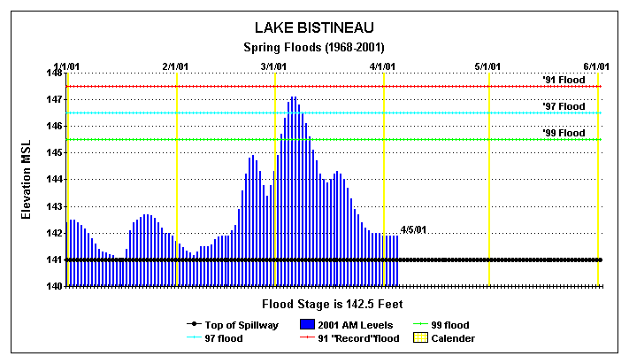
weeks of April. Lake Bistineau rose to near its flood record set during
1991 and Loggy Bayou was affected with severe flooding due to high
inflows from Lake Bistineau, Red Chute Bayou, and Flat River as well as
backwater from high water on the Red River.
Significant flooding returned during January 28th and 29th of 1999 as
very heavy rainfall of six to eleven inches resulted in several
east-central Texas rivers and northwest Louisiana to rise to near their
floods of records. Wallace Lake in south Shreveport set a new pool stage
record with some 50 homes flooded.
Decaying tropical cyclones have also produced significant floods across
the Shreveport HSA. Some of the more memorable storms include the
unnamed storms of August 1849, June 1902, and July 1933. Rainfall
amounts of up to sixteen inches in a twenty-four hour period were common
across northwest Louisiana and east central Texas during July 23rd
through the 25th of 1933. Other notable tropical cyclones include
Hurricane Bonnie in 1986, Tropical Storm Allison in 1989, and Tropical
Storm Arlene in 1993.
Other major flood years on the Red River and its tributaries include
1871, 1890, 1892, and 1908 from records at Arthur City, Texas, Fulton,
Arkansas, and Shreveport and Alexandria Louisiana.
The following chart shows the lake levels reached during the major
floods
on Lake Bistineau during from 1968 to date. Unfortunately, records
were
not kept prior to 1968, so if anyone has any information on the flood of
1958
please share it with us. Contact me at jhinton@bayou.com
|